
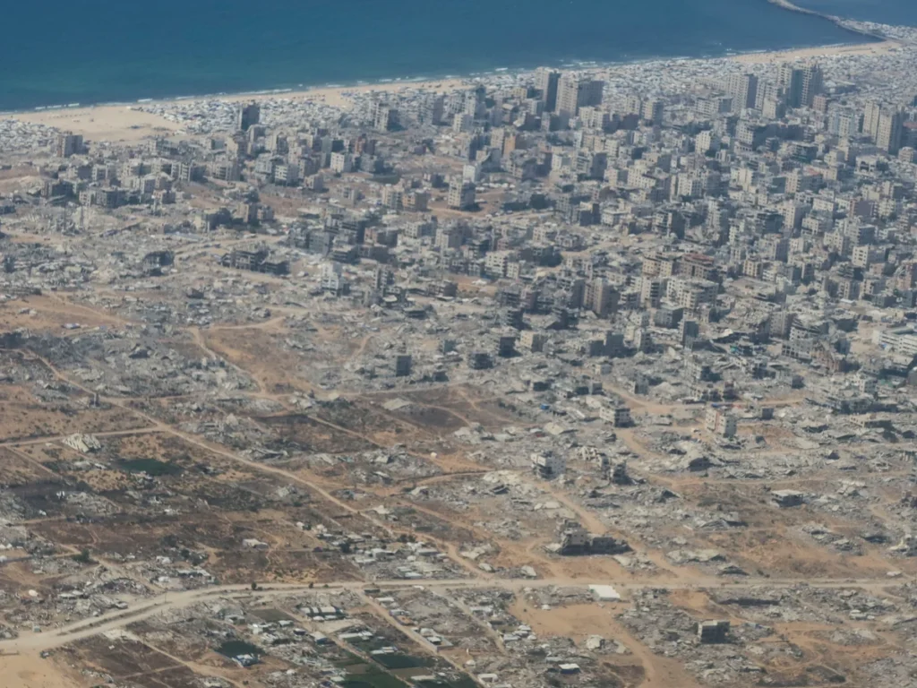
Gaza Herald _Satellite imagery and firsthand accounts from Gaza paint an increasingly alarming picture of life after the October 2025 ceasefire. While aerial images reveal sprawling tent camps packed into ever-smaller areas, testimonies from displaced Palestinians describe repeated displacement, constant fear of approaching Israeli-designated buffer zones, and worsening health and security risks.
An analysis by Al Jazeera’s Open Source Investigations Unit shows thousands of tents concentrated west of what has become known as the “Yellow Line”—an Israeli-designated boundary that continues to reshape where Palestinians can live. As restrictions expand, more families are forced to abandon their shelters or remain dangerously close to military-controlled areas.
Crowded Camps Fuel a Public Health Emergency
The humanitarian crisis extends far beyond overcrowding.
Displaced residents report increasing infestations of rats, snakes, mosquitoes, and other insects as soaring summer temperatures combine with deteriorating sanitation services and contaminated wastewater. The cramped living conditions, largely invisible from satellite imagery alone, have created an environment where disease spreads rapidly.
More than two million Palestinians remain confined to a shrinking portion of Gaza. Under the ceasefire arrangements that took effect on October 10, 2025, Palestinians have largely been restricted to areas west of the “Yellow Line,” while Israeli forces maintain control over territory to the east—an area covering roughly 53% of the Gaza Strip.
Recent satellite images also suggest that the space available for civilians continues to contract as Israeli military-controlled areas expand.
Residents and local observers increasingly refer to a newly emerging “Orange Line,” describing what they say is the gradual westward expansion of Israeli control that has further reduced the land available for displaced families.
Satellite analysis dated July 15 indicates that Israeli forces have constructed approximately 30 kilometers (19 miles) of earthworks and defensive barriers across Gaza’s five governorates since November 2025. In several locations, these fortifications extend beyond the previously established boundary.
Families Forced to Flee Again
Residents of Deir al-Balah say Israeli authorities moved the Yellow Line approximately 300 to 350 meters farther west on July 17, bringing additional farmland and residential neighborhoods within restricted areas.
The change forced numerous families to leave once again and relocate to already overcrowded camps.
Videos from eastern Deir al-Balah show families hurriedly packing their belongings as the boundary approached their homes.
“We’ve been displaced again because of the Yellow Line,” one resident says while loading his family’s possessions.
Another describes living under constant fear, uncertain whether his family will be forced to move again.
Nowhere Left to Go
The cycle of displacement continues across Gaza.
In Gaza City’s Zeitoun neighborhood, the United Nations reported that more than 30 families were displaced after tents near the Yellow Line were destroyed.
Satellite imagery from the area shows densely packed shelters located only a short distance from the restricted zone, placing families at continued risk from nearby military activity.
Residents interviewed during a local media tour described sleeping in the streets after evacuating their shelters.
“We’re displaced, and now our homes are inside the Yellow Line,” one man says.
Others described being unable to leave their camps to buy food or collect water safely.
One resident said he was shot while attempting to purchase bread, while others reported ongoing gunfire and severe shortages of drinking water and basic supplies.
For many families, the danger no longer ends at their tents. Even obtaining daily necessities has become a life-threatening journey.
Isolation, Disease, and Constant Fear
The United Nations says continued military operations and the expansion of restricted zones are forcing additional waves of displacement while leaving civilians with fewer places to seek safety.
According to the UN Office for the Coordination of Humanitarian Affairs (OCHA), families fled displacement sites in southern Gaza in early July as Israeli tanks advanced nearby amid reports of gunfire and casualties.
Those unable to relocate remain trapped in overcrowded camps where poor sanitation, contaminated water, and inadequate hygiene supplies have contributed to outbreaks of skin diseases affecting both children and adults.
In Jabalia refugee camp, residents say Israeli gunfire remains a constant threat, while access to water has become increasingly restricted after the Yellow Line moved closer to residential areas.
Videos from the camp show concrete barriers marking the boundary only meters from homes and roads once used by water trucks.
Residents say areas that were previously accessible have effectively become off-limits because of the danger.
The Human Cost of Shrinking Space
The consequences of Gaza’s shrinking civilian areas continue to mount.
According to OCHA, the UN Human Rights Office has verified the deaths of 196 Palestinians—including 43 children and 18 women—in reported Israeli attacks near the Yellow Line between October 10, 2025, and early April 2026.
Meanwhile, Gaza’s Ministry of Health says that from the start of the ceasefire through July 25, 2026, 1,191 Palestinians have been killed and 3,853 injured in Israeli airstrikes, shelling, and military operations across the territory.
For Gaza’s displaced population, satellite images tell only part of the story. On the ground, every expansion of the Yellow Line means less space to survive, another forced displacement, and another reminder that even the places meant to offer refuge remain shadowed by danger.

