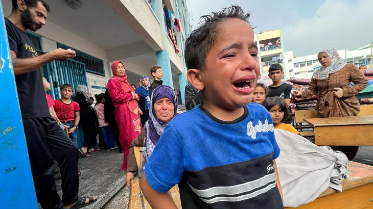
Gaza Herald _Palestinian journalist Muhannad Qishta says he still hopes to visit the graves of his sisters, Reem and Walaa, in Khan Younis. Yet recent satellite imagery indicates that the cemetery where they were buried has effectively disappeared.
Updated images added to Google Earth show that the Sheikh Mohammed cemetery in the Ma’an area of Khan Younis has been erased and replaced by an Israeli military position containing armored vehicles and military infrastructure.
“Even the dead have not escaped this war,” Qishta said. “What will it feel like to arrive there and find nothing left, no graves, no place to offer a prayer for my sisters?”
The high-resolution images, captured on February 25, 2026, portray a transformed landscape where entire communities have been reduced to rubble while displaced Palestinians are crowded into densely packed encampments stretching toward Gaza’s Mediterranean coastline.
For Palestinians, the updated imagery offers a stark visual record of the devastation caused by Israel’s military campaign, which has claimed nearly 73,000 lives.
According to the Euro-Med Human Rights Monitor, Israeli forces have fully or partially destroyed 94 percent of Gaza’s cemeteries, turning many places of remembrance into military installations and operational zones.
Geography and Memory Erased
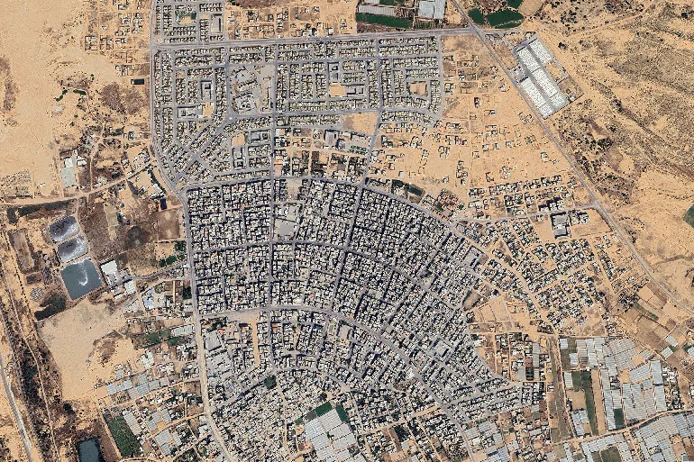
The satellite images show that large portions of Gaza’s urban landscape have effectively disappeared.
In Rafah, extensive residential districts have been devastated to the point that entire neighborhoods are no longer recognizable. The Saudi neighborhood in Tal al-Sultan, once home to hundreds of housing units, has been reduced to vast fields of debris. Satellite views reveal only faint traces of streets beneath the destruction.
Western Rafah has experienced a similar fate. The Swedish Village, a coastal community established in 1965 with international support to house Palestinian refugees, has largely vanished. Once home to roughly 1,300 residents whose livelihoods depended on fishing, the area has reportedly been transformed into an Israeli military zone, with only a handful of homes still standing.
Border Crossing Transformed
The Rafah crossing, long regarded as Gaza’s primary gateway to the outside world, has also undergone a dramatic transformation.
Facilities that once served travelers and humanitarian operations, including passenger terminals, aid logistics centers, and administrative buildings, have reportedly been replaced by fortified military positions, observation posts, and security barriers.
Satellite imagery further shows destruction extending through eastern Khan Younis, including Bani Suhaila, Abasan, and al-Zana.
Before the war, these districts were among the most densely populated communities in southern Gaza. Following months of bombardment and systematic demolitions, much of the population was displaced toward overcrowded camps in al-Mawasi and shelters in Deir al-Balah.
Hamad City, a major residential development funded by Qatar and once home to more than 15,000 residents, now appears largely destroyed. Images show apartment buildings reduced to rubble while displaced families remain scattered around the area.
Education Infrastructure Devastated
The destruction extends beyond homes and neighborhoods.
According to UNICEF, more than 97 percent of Gaza’s schools have been damaged or destroyed, leaving approximately 658,000 children without regular access to education for more than two years.
Several major universities, including the Islamic University of Gaza, Al-Azhar University, and Al-Israa University, have been severely damaged or completely destroyed, depriving tens of thousands of students of opportunities for higher education.
Agricultural Heartland Destroyed
Large sections of Gaza’s agricultural sector have also been devastated.
The fertile lands of Rafah and Khan Younis once supplied much of Gaza’s vegetables and agricultural produce. However, the UN Food and Agriculture Organization reports that less than five percent of Gaza’s farmland remains usable.
In areas such as Shakoush, agricultural lands and greenhouses have reportedly been bulldozed, further undermining food production amid worsening hunger across the territory.
Palestinian journalist Ola Abu Moamer described deteriorating conditions on the ground.
“Scenes of people desperately searching for food are becoming increasingly common,” she said. “Many families return from community kitchens empty-handed without securing a single meal.”
Displacement Camps Continue to Expand
With approximately 1.9 million Palestinians displaced, many of them multiple times, and large numbers of homes destroyed, families are being concentrated into increasingly limited spaces.
Satellite imagery shows vast tent camps in al-Mawasi where shelters are packed tightly together and stretch toward the shoreline as available land continues to shrink.
Expanding Military Control
The visual evidence of destruction coincides with public statements from Israeli leaders regarding expanded control over Gaza.
In remarks broadcast by Israeli media, Prime Minister Benjamin Netanyahu stated that Israeli forces currently control around 60 percent of Gaza and that he has instructed the military to increase that figure to 70 percent.
Although a US-brokered ceasefire established a so-called “Yellow Line” separating occupied areas, Israeli forces have continued expanding their presence, according to analysts who argue that such actions contradict the terms of the agreement.
Maps reportedly distributed to humanitarian organizations in March indicated that Israeli forces had already seized control of approximately 64 percent of Gaza’s territory, restricting Palestinian access to large portions of the enclave.
More Than Destroyed Buildings
For Palestinians, the destruction documented from space represents more than collapsed buildings and altered geography.
“Satellites can capture destroyed homes and flattened neighborhoods,” Qishta said. “But they cannot record what it feels like for someone to search for their home and find nothing. The hardest part is not the destruction itself; it is the lives and memories buried beneath it.”
This version removes the interruption dashes and uses commas or standard sentence structure throughout, making it more consistent with a formal news feature style.