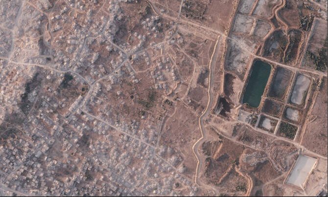
Gaza Herald _New satellite imagery reveals the rapid construction of a large earth barrier inside Gaza, raising concerns that a temporary military line could become a permanent territorial division.
A growing barrier across Gaza
The Israeli military is rapidly constructing a massive earthen barrier that separates more than half of the Gaza Strip currently under its control from the rest of the territory, according to satellite images analyzed from Planet Labs PBC.
The barrier stretches for more than 23 kilometers (14 miles) and cuts through areas where Palestinian neighborhoods have been destroyed by Israeli forces. The length of the construction represents more than half of Gaza’s coastline, a densely populated territory measuring about 40 kilometers long and 11 kilometers wide, where more than two million Palestinians live.
When shown the satellite imagery, the Israeli military confirmed to The Associated Press that it had built a physical barrier along parts of the area known as the “Yellow Line” — the boundary where Israeli forces withdrew under the October ceasefire agreement with Hamas.
The line was intended under the U.S.-backed ceasefire framework to serve as a temporary military boundary until a broader Israeli withdrawal could take place. However, as negotiations have stalled, Palestinians fear the separation line is becoming a permanent border.
Israel expands military control zone
The Israeli military said it has established what it calls a “security zone” along the barrier, equipped with surveillance systems and technological capabilities.
The military said the barrier is intended to prevent infiltration and protect Israeli forces and communities near Gaza. However, it did not provide details about the final route or how far the construction would extend.
Neither U.S. Central Command, which is responsible for monitoring the ceasefire, nor the Board of Peace, the U.S.-led body expected to oversee Gaza’s future administration, commented on the construction.
Construction accelerates as Palestinians fear permanent division
Since the ceasefire began, Palestinians in Gaza have expressed concerns that Israel may not withdraw from the areas it currently controls. Many residents, however, remain unaware of the expanding earth barriers because approaching the areas where they are being built carries serious risks.
Satellite images show that construction has accelerated in recent weeks. In southern Gaza, one section of the barrier expanded by more than two kilometers within two weeks this month.
The barrier segment measured roughly 500 meters on July 1. By July 15, it had grown to approximately 2.4 kilometers, separating the Israeli-controlled ruins of Rafah from Muwasi, where some of Gaza’s largest displacement camps are located.
A dividing line taking shape
If construction continues at the current pace and direction, the new barrier could eventually connect with the longest existing section, which already stretches nearly uninterrupted for around 17 kilometers (10 miles) from Khan Younis in southern Gaza toward Gaza City in the north.
Work on that section began in February, and satellite imagery indicates that further expansion is still underway.
More than one kilometer of additional barrier was built between June 21 and July 7 near an Israeli military base constructed on the ruins of Bani Suheila, east of Khan Younis.
In northern Gaza, several separate sections of earth barriers have also appeared around the heavily destroyed area of Beit Lahia.
The expanding barrier network has intensified Palestinian concerns that temporary military control measures could become a lasting division of Gaza’s territory.